Saturday, July 25, 2015

Day 8 Kings Canyon to Alice Springs

A long day of driving again today, mostly in the drizzling rain. After not a lot of sleep (the hot water unit in the toilet block kept us awake as it continually cycled on and off noisily), we headed off straight to Alice Springs today, with only a couple of 10 minute stops at roadhouses to fuel up, and grab a bit to eat out of the caravan. That is one thing we do love about our van, the inside ceiling is high enough (when not popped up) to allow entry to grab something out of the fridge, or to sit inside and have some lunch.

So after about 479 kms, and about six hours driving time, we arrived in Alice to brilliant sunshine, and 20 degrees – very welcome!  We are staying at the MacDonnell Ranges Caravan Park (Big 4) which is huge and lovely. Three pools, a waterslide, go-kart hire, shop, tour desk, cafĂ©, huge jumping pillows, games rooms, massive bbq area seating heaps of people (tonight a free demo on playing the didgeridoo), tomorrow a free pancake breakfast.  The kids are wrapped to have some grass beneath their feet again, and some decent playgrounds and areas to explore. Brendan and I are glad we are having three nights here, so no need to pack up again for a couple of days.
As we drive Lily and Sam have been enjoying reading lots of Jacqui French books – she writes a great fictional series built around some Australian icons (Waltzing Matilda, the road to Gundagai, the girl from Snowy River, etc). They both love them, and it’s a great, fun way to learn about some Australian history.

Of course, as well as the books, each day (on the long driving days) the kids can have a couple of hours to play their iPads. The current favourite is still Minecraft which they can play against/with each other. Brendan (my gadget man), has set up a portable small network so they can access each others iPads (wirelessly), and have access to the many hundreds of movies and music tracks (simultaneously and individually) stored on the tiny hard disk stored in the car, without the need for cables or anything else.
Brendan and I have been listening to an audio book written and narrated by author and photographer Terry Underwood called “In the Middle of  Nowhere”.  It’s a wonderful insight into life on a very remote WA cattle station, and is fascinating and very absorbing. If you are interested in how life in the outback is lived or even just enjoy a good yarn, I thoroughly recommend reading this book - http://www.terryunderwood.com/books.htm  It revolves around the story of two people who fell in love in unusual circumstances (a city girl, a country boy) and  followed their hearts and were committed to building their lives together in the remote outback by building themselves  a home, a family, and a business from nothing. Our kids were also interested listening about how their children were schooled (via School of the Air on the radio), and how when accidents happened, the only option was to fix it yourself, or call the Flying Doctor Service. A  good lesson for us all.
Now, back to Alice Springs. Brendan and I last visited The Alice over 20 years ago, so have noticed a few changes. Alice is a sprawling outback city, surrounded by the MacDonnell Ranges. Almost the middle of town is the Anzac Lookout situated on a small hill providing a terrific view of the town, and the dry, sandy bottomed Todd River. As we remembered from our last visit, lots of Aboriginals still appear to either live or sleep in the river bottom in the open air right in the centre of town.  Alice is well serviced by three shopping centres, the Todd Mall (lots of galleries, and restaurants), and the usual facilities found in most large towns.  There is lots of things to see and do here, and I look forward to sharing them with you over the next few days.


Day 7 Uluru to Kings Canyon

(no phone service yesterday at Kings Canyon, so the post is a day behind).
Up early again, packing up in the rain, and off to Kings Canyon in the Watarrka National Park, only a 3 ½ hour drive this morning. We arrived around 11.30am, and settled ourselves into the only caravan park in the area – Kings Canyon Resort (a large area made up of a hotel, petrol station, several lodges, a general store and an outback bbq complete with resident country singer). The area is stunningly beautiful, and our caravan site faces out onto the majestic Kings Canyon. The park is lovely, spaciously arranged among the white barked gumtrees, with abundant bird life all around us. There are a few wild dingos wandering around the park, and we were warned not to feed them. They are so pale in color they blend in with the native grasses surrounding them.
 
 
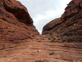
After an early lunch, we drove the 10 minutes out to where the walking tracks start. There is a choice of three major walks – Kings Canyon Rim Walk (6km loop – 3-4 hrs, hard), Kings Creek Walk (2km – 1hr, easy), and Kathleen Springs (2.6kms 1.5hrs, easy).  Having done the walk about 20 years ago, and knowing just how spectacular it was, we opted for the difficult, 6km steep walk, climbing straight up the side of a cliff, and then around the Canyon Rim, before descending down to the carpark again. (The photo below doesn't show it, but this is an almost vertical climb).


 About half way along the walk is the aptly named ‘Garden of Eden’ at the bottom of the canyon, a delightful area of cool waterholes and riverine vegetation, such as palms and cycads. From frogs in the waterholes, to the tiny bright green birds zipping around the trees above our heads, the area was a hive of industry.


The various steps and viewing platforms help you experience stunning views of the sheer canyon walls, and the majestic towering cliffs all around you.    Although we completed most of the walk in the rain, it dampen our enthusiasm to appreciate this beautiful part of our country.


The kids thoroughly enjoyed the walk, and although steep, difficult and physically exhausting in some places, the reward of the view around us was more than worth the effort. All of us decided that this walk was far more spectacular and beautiful than yesterdays walk around Uluru and Kata Tjuta. Definitely one for your bucket list!
 
We were back at the caravan park by 3.30pm, and for the first time in a week had some time to catch up on some washing, and a few other things in the caravan. The rain has set in, so we tucked in for the night, and the kids have been busy doing some school work. Sam is busy updating an excel spreadsheet containing all our food, accommodation and fuel costs, and Lily is reading (constantly!), and has been doing one of Sam’s old Year 3 Naplan exercise books (lots of maths) which she loves. No phone service or internet here at all, so we are feeling very remote and cut off from the world!

Thursday, July 23, 2015

Day 6 Uluru and Kata Tjuta

Up early and off to the supermarket in town (5 mins away) to buy some supplies – rolls, ham, water, choc bars – all the essentials for our big walk.  Then a quick wander around the resort shops (a little didgeridoo x 2 carved out of bamboo that somehow I got talked into buying for the kids). I resisted all the nice candles, pottery, clothing and other items. Actually amongst the cheap tourist stuff, there was also some really nice things. Then it was off to the Cultural Centre at Uluru (20kms) to buy a couple of souvenirs for the kids.


Sam was very taken with a hand carved aboriginal lizard of local mulga wood, and Lily chose some handcrafted wooden music/rhythm  sticks (which I might add she has been banging away on and singing ever since!).  Then off to meet the ranger (along with heaps of other people) at 10.00am to start the Mala (an animal like a small wallaby) guided walk. Off we went, to near the base of Uluru, amongst the acacia trees, stopping at caves, rock paintings, and aboriginal food sources.


The ranger went to great lengths to explain all the food available if you know where to look – from cooking the acacia seeds under the coals until the hard casing splits, then harvesting the seeds, and grinding them down and mixing them with water to make  a kind of bread, to different bush fruits, witchetty grubs, native honey found on various flowers, and even digging down to find the special species of frog that can live under the sand during the times of no rain, with their bellies full of water – a great little canteen if you know where to look! We were also told to look out for the signs around the rock base, advising of some sacred areas where photography is not permitted.


We listened to dreamtime stories, and local laws about the rock, and local customs. Then it was off to explore the area on our own. Sam and Lily did a great job walking around the entire rock (about 12 kms), and it was fairly warm today – about 25deg in the sunshine.  The whole walk took us about 3.5 hours, no mean feat for little legs. Of course this was helped along by various bribes of lolly snakes and violet crumbles!


The different geological faces of the rock were fascinating, from smooth sandstone areas, to snake like grooves, to small pitted holes and large caves. The sheer vertical walls in places made us gasp with their enormousness, and we enjoyed walking through the acacia woodlands, the bloodwoods and various native grasses. With the red sands beneath our feet, and the amazing monolithic form of Uluru ever present, it was a sight we will all never forget. Something every Aussie should strive to do at least once!
 
 
Next it was off to Kata Tjuta (The Olgas) which is 50km from Uluru. Although the two rock formations of Uluru and Kata Tjuta appear similar from a distance, in color and composition, when you walk up close to each of them, they are very different.
 
 
We did the gorge walk at Kata Tjuta, across the mighty rock formations, into the treed gullies, fascinated by the huge, conglomerate rock layers of gravel, pebbles and boulders of basalt and granite which have been cemented together by sand and mud over thousands of years.  Kata Tjuta rises 546 m above the plains and contains 21 types of mammal, 73 reptile, 170 bird, and 4 frog species.

The plant life is astonishing with over 400 flora species in the area. With a temperature reaching 47deg in summer and down to -7deg in winter, the fact that the animals, let alone the aboriginal people can survive in the huge variance of temperatures, out in the open, is amazing.


So, after our big walks, it was back to the camping area for a welcome hot shower and a change of clothes, then we treated ourselves out to the local hotel Outback BBQ smorgasbord for dinner.  So, it was a choose your proteins from the service area, then take them to the BBQs to cook yourselves, then load up your plate with a variety of salads and hot foods (corn, roast potato, onions). So, we chose to eat kangaroo, crocodile, emu, prawns and barramundi – oh yum!  Both kids tried everything, liking the barramundi and the kangaroo the best.

So, then after a big day, there was time for a quick update of everyone’s blogs, travel journals, etc and off to bed.
By the way – if you want to follow the kids Track My Tour maps – have a look here and leave them a message. They would love it.

Lily -  http://trackmytour.com/rFXd8

Wednesday, July 22, 2015

Day 5 Coober Pedy to Uluru (Ayers Rock)

We were packed up and gone by 7.30am this morning in anticipation of a long day on the road. 730kms in fact. The ever-changing landscape is quite fascinating, from empty plains, to low scrub, to trees, back to red desert plains. We stopped at the huge Marla roadhouse, which is a major turning point off the Stuart Highway for those heading to Oodnadatta & Lake Eyre.

 
The roadhouse, as well as selling fuel, also has a fairly large supermarket, caravan park (complete with pool), large motel, an aboriginal art gallery, and a nice treed, grassed area.  I counted 25 caravans all lined up either fuelling up, or taking a break before heading off on their journeys again, like us.

 
After a fuel up and a stretch of our legs, we drove through to the next major roadhouse, Erlduna Roadhouse and the turning point off the highway to Uluru. This was also a large area of a roadhouse, restaurant, tavern, caravan park and motel, and even an attached emu farm. Something different to look at while we ate our sandwiches!
 

Finally, at about 4pm,  we arrived at our destination for the next two nights, Yulara. Yulara is the service town for nearby (20km away) Uluru – or Ayers Rock as it used to be known. It  mainly consists of resorts, one caravan park, a few tourist shops, and a camel farm. There is also an airport where a lot of international tourists fly in.

After a quick check in, we unhitched the van, and jumped back in the car for the 20km drive out to the Rock, passing through the Ranger station and paying entry to the National Park (3 day pass $25 per adult). Then it was off to the Cultural Centre to find out about the local tours and forthcoming weather conditions, etc.  We found out there would be a guided walking tour (Marla walk) by the Ranger at 10.00am the next morning, involving talks, cave visits, etc, so that’s what we decided to do as part of our own base walk around the whole rock (10kms).
 
The boys briefly thought about doing the rock climb, but staff actively discourage anyone from climbing it these days, and tomorrow it was closed to walkers. Three weeks ago a Korean tourist had almost fallen to his death, after attempting a shortcut off the main path, and so the staff were still a bit jumpy. The manager was telling me that it was only by pure chance that the Dalai Lama was visiting the next day, so they happened to have the special police onsite, who were able to extricate him from  crevice with a fractured skull and pelvis after 26 hours! Yipes!

Sam was fascinated by the amazing hand carved items in the gallery by the local indigenous people, and stood watching a short video showing how they burned patterns into carved wooden objects, until we dragged him away. Lots of history and culture to take in, and absorb. 

Then it was off to the sunset viewing car park, to watch what we had driven all this way for – the ever-changing, fascinating Australian icon, Uluru. As we watched, the rock changed from orange, to purple to brown in the darkening light. Quite an amazing experience.  Then it was home for a bbq at the caravan park, and into bed reading for another adventure in the morning.


Tuesday, July 21, 2015

Day 4 - Coober Pedy

*don't forget you can click on any photo to see a larger version of it.

A big day exploring this very strange, but fascinating place. It’s very hard to describe to anyone who hasn’t been here. The landscape for miles in every direction is dotted with tiny little piles of pale pink colored tailings (dirt out of the mines), where thousands of people have tried their luck hoping to hit the big time, and find a good vein of opal.


The Big Winch lookout in the centre of town gives a birdseye view over the town. Today 50% of the town’s population live in houses underground (the temp is a stable 22-25 deg all year round, and with temps hitting the 50s in the summer I don’t blame them!).  In 1920 opal was discovered and it was renamed Coober Pedy from the aboriginal words ‘kupa piti’ meaning ‘white man in a hole’. Very apt!

The population now is about 3500, with 60% people of European heritage, representing 45 nationalities. The area is still very rich in many kinds of opal and produces 85% of the worlds opal supply. There is a designated ‘public noodling/fossicking area’ where tailings from the surrounding mines are dumped, and anyone can have a go at looking through the large piles of rock for opal. The kids were fascinated by poking around in the dirt, and we all managed to find a little bit of color.


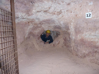
We visited the Old Timers Mine and did the underground tour which was great. Donning miner’s hats we descended below the surface and saw how the miners would dig down huge vertical shafts, then creating footholes for themselves as they went, descended deep down into the earth, picking as they went, looking for that elusive opal.
 
 
There was also a display of an underground house, complete with fireplaces, kitchen, tv room, bedrooms  - if you want another room in Cooper Pedy, you just dig one out!
 
At the mine entrance is also a public noodling area where Lily and I tried our luck. This was actually the best place in town to find small pieces of colored opal, and I must say it bought back a lot of memories from my childhood, where as kids we were carted around all over the place with my gemstone fossicker/jewellery maker father, looking for crystals, gems and opals. As a matter of fact, this very day he is in Yowah in outback Queensland, doing just that!


We visited a couple of underground churches, cleverly dug out of the rock, decorated with mining relics and precious stones. This one is the Catholic church.


Well, one other thing you don’t see everyday is a desert golf course. This well maintained course, is of course played over sand and dirt, but does has clear teeoff points for every hole. Mmmmm….

The main street is lined with many opal shops (of varying quality and some are more ‘outback’ than others). As you would expect, they make their living from the thousands of tourists that flock here, so some of them are very ‘hard sell’ as soon as you walk in the door.


Sadly, the aboriginal population is not seen in its best light here, and many youths are lying around the public buildings, or shops. A bit confronting for the kids, but part of life up here in the outback.
After obtaining a $10 permit from the Info Centre we drove 23kms out to the Breakaways Reserve – an area of colourful low hills that rise up out of the flat desert plains. There are a few lookout points including one called ‘The Castle’ and ‘Salt  & Pepper’ – see if you can guess which is which…


We also viewed the dog fence, an amazing 2m wire mesh barrier fence that stretches for over 5300kms across three states, to protect the sheep country in the south from the native dogs (dingos). Today the landscape was covered with tiny yellow wildflowers that stretched as far as the eye could see, covering the moonscape-like plains that have  been the setting for many movies such as Mad Max and Ground Zero.


Well after all that, and maybe visiting just a few more opal shops and aboriginal galleries, we arrived back at the caravan, where I thought we were all going to have a rest, and then have some dinner. But, Sam was soon begging his dad to take him back to do some more fossicking  in the public noodling area (looks like he’s been bitten by ‘opal fever’!).

Monday, July 20, 2015

Day 3 Wilmington to Coober Pedy

What a lovely quiet campsite, just the twittering of the birds to wake up to this morning. It was a very cold night, below zero and ice on the windscreen, but we were warm and toasty in our sleeping bags and doonas. Clever Brendan carefully placed some leftover house sarking/foil insulation (“See Michelle, I told you I was saving it to use for something one day!”) underneath our beds, keeping the cold and damp out.
We left Wilmington, and drove through scenic Horrocks Pass, over rolling hills, past majestic twisted ghost gums, and ½ an hour down the road arrived at Port Augusta. After visiting the supermarket and stocking up on supplies for the next week, we visited one of the places on my list, and it did not disappoint. The Australian Arid Land Botanical Gardens (free admission) were established in 1993, and cover 250 acres. There are several loop walks possible taking you through bushland, woodlands, sand dunes and desert areas, all providing views over the spectacular Flinders Ranges.


The kids especially enjoyed seeing some of the rarer plants and reading the boards about plants such as the “poached egg plant”, the “needle bush” and the amazing array of medicinal plants used for a variety of ailments. Some of the flowering gums were just stunning with their bright green leaves, dark red stems and amazing huge pink and green gumnuts bursting with different colored flowers. The birdlife was also plentiful – it was a very special place to visit.
 
One of the reasons I wanted to visit was in the hope of seeing the Sturt Desert Pea in flower – this amazing plant pops up out of barren looking ground displaying its huge vivid red petals and glossy black centres. I was pleased to see it growing in abundance.

Sam spotted a ‘Sleeping Lizard’ sunning itself beside the path.

After Port Augusta the landscape changes drastically from woodland to flat plains, red dirt, very scrubby low groundcovers, and not a tree in sight in any direction. We veered off the main Stuart Highway by 6kms to visit the interesting town of Woomera.
Woomera was established in 1947 for the launching of British experimental rockets. The testing range extended across 270,000 square kilometres. Today the whole town is administered by the Department of Defence, and still services the testing range. Open to the public now, there is a caravan park and hotel, post office and chemist. We spent some time looking around the missile park and old planes and rockets – very interesting.


Then it was back in the car for the long drive to Coober Pedy , just stopping at the Glendambo Roadhouse for fuel. We didn’t arrive in Coober Pedy until 6pm in the dark, and were happy to quickly set up the caravan in the Opal Hotel Caravan Park (small, dirt only sites, surrounded by a large fence), and make ourselves some dinner.